The following resources use realistic graphics, animation, and aerial footage to illustrate these unique geologic features, the complex movement of water to bedrock aquifers and streams, and the vulnerability to contaminants like nitrate-nitrogen (nitrate).
Use the videos, infographics, and additional resources to understand:
- How rain and melting snow is directly connected to aquifers, springs and streams in southeast Minnesota
- How proper well construction affects the quality of drinking water
- Why adjacent wells can have different nitrate testing results
- Why nitrates are increasing in certain streams
- How land use decisions can impact groundwater contamination directly underground and also miles away
The videos and infographics highlight the groundwater movement through the Root River Watershed in southeast Minnesota. They are examples of how groundwater moves throughout the rest of southeast Minnesota and the Driftless Area.
Videos
The following videos are located on the MDA's YouTube channel. View them individually using the links below or as part of a playlist. Please note that there are two versions of each video. Audio-described videos contain additional narration to describe the key visual features for the benefit of visually impaired viewers.
How groundwater moves in southeast Minnesota [Part 1]
Follow the complex movement of water across three different geologic landscapes in the Root River Watershed. Groundwater contained in aquifers (our primary source for drinking water) can move downward, sideways, and upwards. Note the connection between surface and ground water and the speed at which it travels through various layers of soil and bedrock.
View the video with audio-description.
How contaminants (like nitrate) move in groundwater [Part 2]
After watching Part 1, take a look at Part 2 to understand how contaminants like nitrate-nitrogen (nitrate) move in southeast Minnesota groundwater. This movement differs for the till, karst, and bluffland karst landscapes found in this area. Animations also demonstrate how grout and well casing affect the movement of contaminates to a drinking water well.
View the video with audio-description.
How groundwater moves in southeast Minnesota by landscape
These short videos animate and narrate information contained on the infographic posters described below.
| Videos with standard narration | Videos with audio description added |
|---|---|
| Till landscape | Till landscape - Audio described |
| Karst landscape | Karst landscape - Audio described |
| Bluffland karst landscape | Bluffland karst landscape - Audio described |
Infographics
These resources illustrate a cross-section of the till, karst, and bluffland karst landscapes and capture the key points of water movement. Each image also has a quick response (QR) code for easy access to the corresponding video (located in the bottom right corner). Posters have been distributed to partnering agencies, non-profits, and state parks in southeast Minnesota. To learn where you can view or borrow a poster please contact Jen Schaust, Jen.Schaust@state.mn.us. Electronic copies are available for download below. Higher resolution copies are available upon request.
How groundwater moves in southeast Minnesota: Till landscape
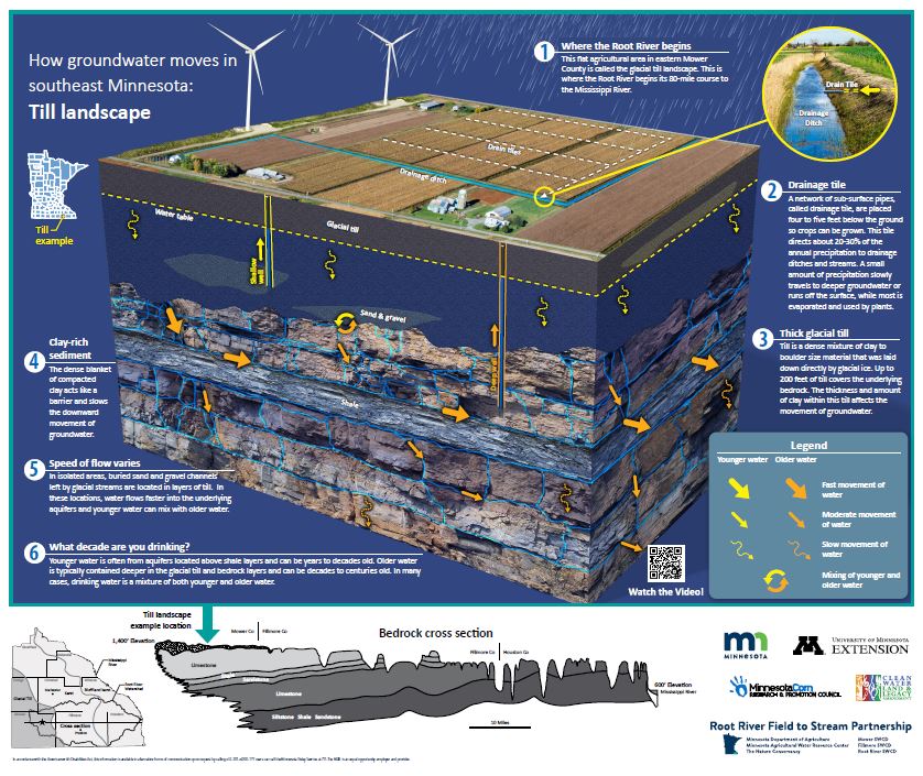
Items available for download:
Till Groundwater Poster (36 in x 30 in)
Till Groundwater Handout (8.5 in x 11 in)
How groundwater moves in southeast Minnesota: Karst landscape
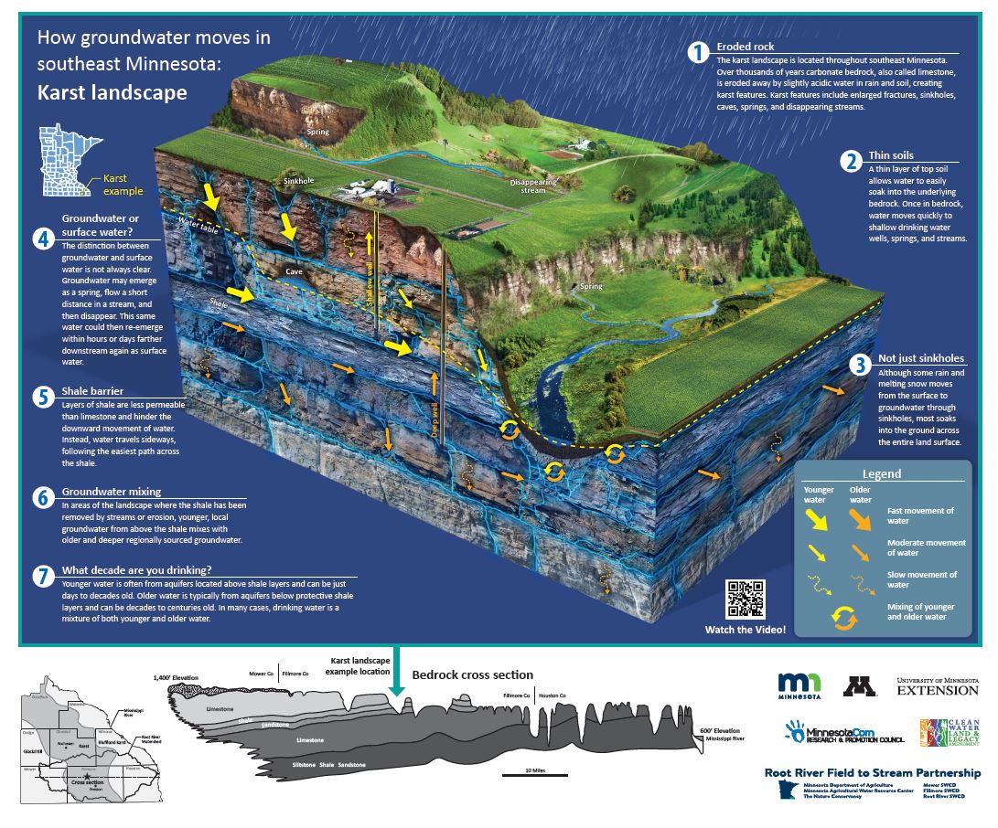
Items available for download:
Karst Groundwater Poster (36 in x 30 in)
Karst Groundwater Handout (8.5 in x 11 in)
How groundwater moves in southeast Minnesota: Bluffland karst landscape
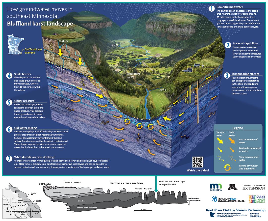
Items available for download:
Bluffland Karst Groundwater Poster (36 in x 30 in)
Bluffland Karst Groundwater Handout (8.5 in x 11 in)
Additional Resources
Place-based learning resources: The Minnesota Pollution Control Agency (MPCA) has created resources for students in Southeast Minnesota. Resources include earth science lesson plans, a separate education kit with a 3D karst model, DVD, and books, and a series of the karst and geology education resources (virtual map, posters, and more). View the Karst and Water Pollution lesson plans (PDF | MPCA).
Partners
- Minnesota Geological Survey
- Minnesota Department of Agriculture
- Root River Field to Stream Partnership
- Minnesota Department of Health
- Minnesota Department of Natural Resources
- Minnesota Pollution Control Agency
- University of Minnesota Extension
- Minnesota Ag Water Resources Center
- Olmsted Soil and Water Conservation District
- Minnesota Board of Water and Soil Resources
Funding for this project was provided from the Clean Water Fund through the MPCA, the Minnesota Corn Research and Promotion Council and MDA's Root River Field to Stream Partnership.