Principal Investigator: Greg Wilson
Co-Investigator(s): David Mulla and Jim Klang
Organization(s): Barr Engineering, University of Minnesota and Kieser &Associates
Local Project Partners: Chisago, Stearns & Washington County SWCDs
Award Amount: $571,719
Start Date: 3/7/2011 | End Date: 4/30/2014
Project Manager: Heidi Peterson
FINAL REPORT is available in the Minnesota Water Research Library
Presentation from the 2014 Soil and Water Conservation Society Conference (PDF)
“As SWCD staff we are all pulled in many directions, by identifying the critical source areas we are able to maximize the efficiency of our time spent in the field.”
“We found that the maps generated through the terrain analysis were a wonderful tool when meeting with landowners. They stimulated a lot of great conversation on farm visits.”
- Stearns County SWCD staff
Goals of the project
The overall goal of this research project is to identify, describe and link a suite of assessment tools that can help identify Priority Management Zones (PMZs) and Critical Source Areas (CSAs) in a variety of soils/ landscapes / climate regions in Minnesota.
This project will develop a compendium of the assessment tools and provide a decision-support system for identifying and delineating PMZs and CSAs. This support system can be used by state and local watershed professionals and will help target conservation practices to areas of the landscape where they will have the greatest environmental benefit. This project will also result in the development of guidance and training materials for field data collection.
Background Information
New Technologies Create New Opportunities
 conservation practices to areas of the landscape where they are needed most. With the increasing availability of LiDAR data for Minnesota, there is greater potential for rapid landscape assessments that help identify PMZs and CSAs for conservation. However, there is a need to evaluate these new technologies more thoroughly in multiple regions of the state and determine their potential value in targeting specific types of best management practices to areas where they will have the greatest environmental benefit.
This project will develop a process for identifying PMZs and CSAs with a focus on evaluation of water-quality impairments within an 8-digit HUC scale. This information can be translated to other regions throughout the state.
What is a PMZ?
Priority Management Zones (PMZs) are regions of the watershed targeted for conservation practices that address disproportionate or large pollutant loads. PMZs can be characterized by three areas of emphasis: source reduction, interception treatment, and in-channel assimilative capacity.
What is a CSA?
Critical Source Areas (CSAs) are defined as portions of the landscape that combine high pollutant loading with a high propensity to deliver runoff to surface waters, either by overland flow or by sub-surface drainage. These areas have a higher likelihood of conveying more pollutants to surface waters than other portions of the landscape.
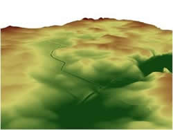
What's LiDAR?
LiDAR stands for Light Detection And Ranging. This technology uses lasers to determine the distance, between the plane equipped with a laser, to an object or surface. This information is used to develop terrain maps and identify different landscape features.
What's an 8 digit HUC?
HUC is the acronym for Hydrologic Unit Code. The Hydrologic Unit system is a standardized watershed classification system developed by the United States Geologic Survey (USGS) in the 1970s. Hydrologic units are watershed boundaries, delineating the area where all the water within it flows to a common area.
Each hydrologic unit is identified by a unique HUC consisting of two to twelve: 2-digit HUCs are the largest and represent an entire region while 12-digit HUC are the smallest and represent a subwatershed.
Project Tasks and Deliverables
Compendium of Assessment Tools
- Identify the various watershed assessment tools that will benefit watershed managers when delineating PMZs and CSAs
- Categorize assessment tools into three groups
- Group 1: lowest level of complexity, primarily consists of screening tools
- Group 2: more complexity than group 1, includes tools such as phosphorus index modeling
- Group 3: most complex, consists of deterministic or process-based models, such as SWAT
- Describe each assessment tool
- Information about who developed the tool and any government agency supporting the tool
- An evaluation of the input needs, complexity of operation, and required training
- A discussion of how the tool will contribute to better PMZ and CSA delineation
Additionally, the compendium will compile or rate the benefits and limitations of each tool or model.
Test Chosen Assessment Tools in the Field
This research project will further refine the ability to identify PMZs across a variety of soil/ landscape/ climate combinations in Minnesota.
Develop a Decision/Logic Tree and Refine Selected Assessment Tools/Models
A decision tree will essentially be a guide that conservation professionals can use to link the independent assessment techniques.
Additionally, researchers will provide a discussion about each tool. This discussion will include information such as:
- Rating the individual performance of each individual assessment method, level of training required to use the tool, and potential for the assessment process to be appropriately transferred to other Minnesota watersheds and conservation offices
- Provide guidance on recommended techniques when combining tools, with the goal of efficiency and optimization of PMZs and CSAs
- Create an operation handbook with information about the selection and implementation of PMZ and CSA delineation tools
- Develop preliminary training manuals tested by regional field staff for each of the selected assessment protocols
Partners
Researchers are working closely with local partners to ensure that assessment tools are accessible to those responsible for implementing conservation practices. Partnerships with local resource professionals bring real value to this project and ensure that research goals are met. Researchers are working closely with: