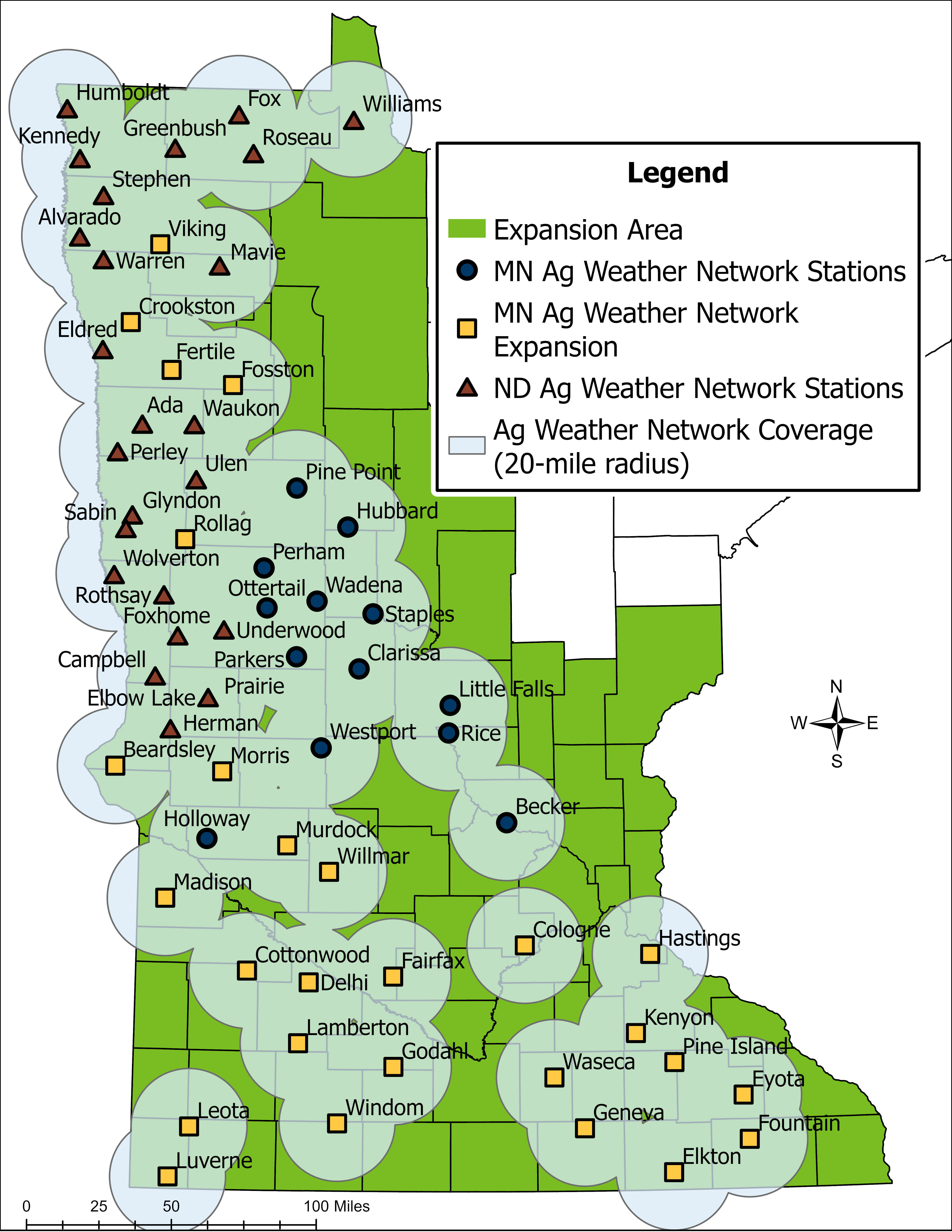
The MDA and local partners operate 41 weather stations across the Minnesota Ag Weather Network (MAWN). Another 24 stations in Minnesota are owned and operated by the North Dakota Ag Weather Network (NDAWN), a longstanding partner that helps deliver consistent, research‑grade environmental data across the region. Together, these networks form a unified system designed to provide accurate, hyperlocal weather information within 20 miles of agricultural land statewide.
All Minnesota station data feed directly into NDAWN, which maintains the public tools and applications that make this information easy to access and use. Minnesota station data are available on the NDAWN website.
Hosting a Weather Station
The network relies on landowners willing to host stations. Each site requires a 30‑by‑30‑foot area (0.02 acres) on land not enrolled in Conservation Reserve Program or the Conservation Reserve Enhancement Program. Stations are intended to operate on each site for at least 50 years. The equipment is research‑grade, built to withstand long‑term exposure so each site remains operational for decades. Landowners interested in participating can complete the Minnesota Ag Weather Station Host Application.
Weather Station Details
Each MAWN station is built for long‑term, high‑quality environmental monitoring. Stations are solar powered and transmit data every five minutes over a cellular network. They measure conditions up to 33 feet above ground and 7.5 feet below the surface, including rainfall, snow, air temperature, humidity, wind, solar radiation, and soil temperature and moisture. All equipment is research grade to ensure reliable, decision‑ready data for farmers, researchers, and emergency personnel.
Network Expansion
In 2023 and 2025, the MDA received a combined $5.25 million from Minnesota’s Clean Water Fund to significantly expand MAWN. This investment supported the installation of 41 new stations to date in partnership with local soil and water conservation districts, the University of Minnesota, and NDAWN. With these additions, MAWN and NDAWN together now provide 65 stations across Minnesota. The expansion strengthens statewide coverage and improves the quality and resolution of data available to farmers, researchers, water‑resource managers, and public safety officials, though achieving full coverage may ultimately require as many as 80 stations across both networks.
Benefits
Accurate, real‑time weather and soil information is essential for modern agriculture. MAWN data help farmers improve irrigation efficiency, optimize manure, fertilizer, and pesticide applications, reduce nutrient loss, and protect surface water and groundwater. The network also supports drought tracking, flood and runoff assessment, and long‑term modeling used in water‑resource planning and environmental stewardship. Over time, MAWN’s growing historical record provides a valuable foundation for research and climate‑related analysis.
Data Collected
- Rainfall
- Air temperature
- Wind direction and speed
- Relative humidity
- Dew point temperature
- Soil temperatures to 7.5 feet
- Soil moisture to 40 inches
- Solar radiation
- Snow depth and snow water equivalent
Tools and Their Uses
MAWN data support several decision‑support tools that help farmers and land managers make informed, timely choices.
Soil‑temperature tools guide fall fertilizer and manure applications, improve nutrient availability for the next crop, and reduce nitrate leaching to groundwater.
Inversion and wind monitoring helps producers detect temperature inversions and rapidly changing conditions before pesticide application, reducing drift and preventing off‑site movement to nearby surface waters.
Irrigation‑scheduling tools estimate evapotranspiration to determine crop water needs, improve water productivity, and reduce the potential for nutrient and manure leaching.
Disease‑risk forecasting identifies periods of elevated disease pressure, allowing producers to apply pesticides only when needed.
Runoff‑risk forecasting predicts potential overland runoff up to 10 days in advance, helping producers delay applications when conditions are unfavorable and keep manure and other inputs on the field and out of surface water.
Weather and Flooding Alerts
Emergency managers and public safety officials also rely on MAWN for real‑time, ground‑level awareness during fast‑moving weather events. Continuous updates on rainfall intensity, soil saturation, snowpack, and wind conditions help agencies assess developing hazards and issue timely flood alerts and extreme‑weather warnings. Cameras mounted on MAWN towers have, in several cases, allowed emergency personnel to visually confirm tornado formation before rotation appeared on radar—providing earlier notice and improving the accuracy of public warnings. By combining localized measurements with live visual information, MAWN strengthens situational awareness and supports faster, more informed emergency response.
MAWN's expansion is made possible through the support of Minnesota's Clean Water Fund.