The U.S. Environmental Protection Agency (EPA) created a Mitigation Menu website to protect listed species from pesticide exposure due to runoff and erosion, help applicators determine when mitigations are required, and what options are available. Pesticide labels with Endangered Species Act (ESA) language reference this site.
The website has a list of steps to determine if runoff/erosion mitigations are required* and, if so, a mitigation picklist to achieve the label-specified point requirements. When planning for ESA requirements, you are encouraged to follow each step from the beginning of the mitigation menu website. To aid in planning and tracking ESA requirements, the EPA has developed a runoff points calculator to help determine mitigation options and when the required number of points for a location has been met. Additionally, the calculator can be accessed through a mobile browser at the Pesticide App for Label Mitigations (PALM).
If mitigations are required by the label, use the mitigation picklist for each site a pesticide product will be used. A minimum number of points from the EPA picklist must be achieved based on a product’s risk to sensitive species and their habitat. The number of points vary depending on the product's potential to cause population-level impacts. Products rated to have a lower probability of causing population-level impacts are assigned fewer points; the maximum number of points that can be required is nine. Many sites in Minnesota may already have points because of their inherent nature (see maps below).
The mitigation menu is designed to be updated as the EPA evaluates additional mitigations and as technology improves. When the mitigation menu is referenced on the label, you must follow the instructions and specifications on the website to comply with the pesticide product label. Once runoff/erosion requirements have been fulfilled, check and follow any more restrictive language on the label and applicable bulletins.
*Certain practices like tail-water return systems, tiled drainage with a control release structure, and permanent berms, if installed on a site, cover all requirements and no additional mitigation points are necessary. For the full list of practices where no additional points would be required, see Step 3 on the EPA Mitigation Menu website.
Mitigation Relief
There are several mitigation options the EPA has included that remain relatively fixed over time, i.e., slope, soil characteristics, how prone a site is to run-off, whether a site is irrigated, and pre-existing practices that meet EPA criteria. Points awarded for these characteristics are not likely to change over time and can be considered as your sites’ “relief” points and can be used to meet the number of mitigation points required by the label. Achieving a total of nine reliefs points for a site will fulfill current ESA runoff/erosion mitigation requirements. The following landscape level characteristics contribute to relief points.
Click on each of the maps below to enlarge.
Runoff Vulnerability
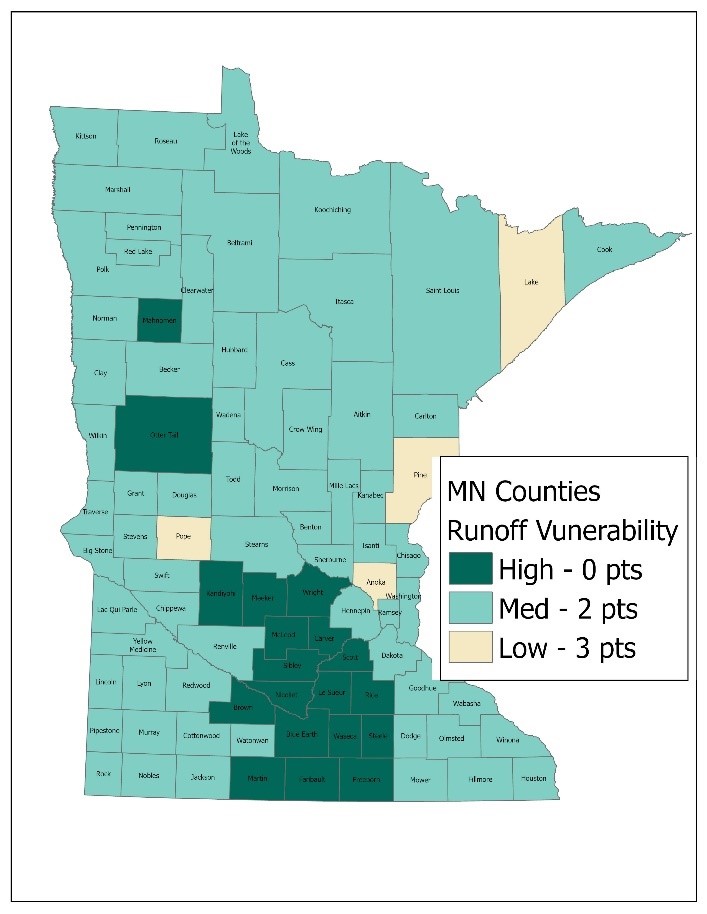
The EPA analyzed geographic regions for runoff vulnerability and assigned each county to a runoff vulnerability category (low - 3 pts, medium - 2 pts, and high - 0 pts). Source EPA’s County List.
Field Slope
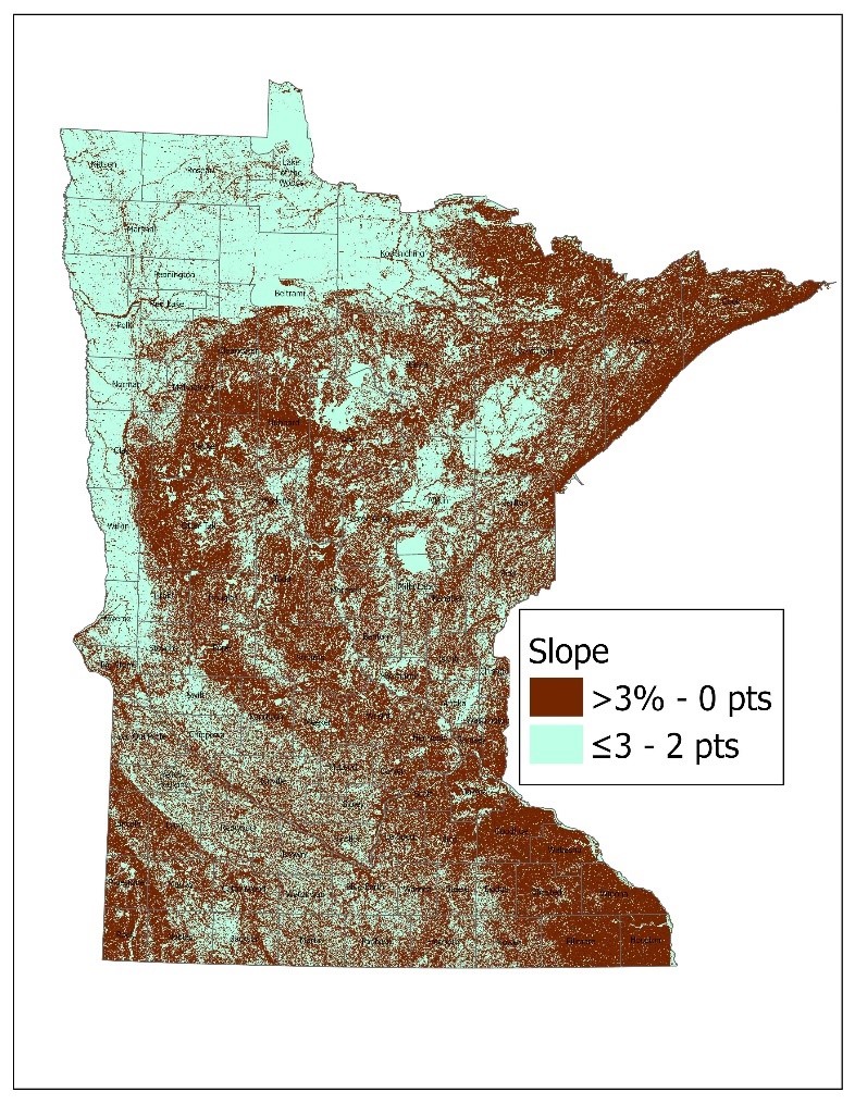
Sites with low slope are less likely have runoff or erosion. Sites with a slope of 3% or less are given two points. No points are awarded for sites with a slope >3%. The USDA's Websoil Survey provides a range of slope for a given area. Consultation with a technical expert is recommended in situations where there are questions about slope. Source USGS Minnesota Digital Elevation Model - 30 Meter Resolution.
Predominantly Sandy Soils
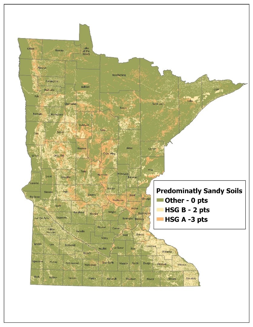
Soils with a predominately sandy composition are more permeable and produce less runoff than soils with high clay content. Soils in the Hydrologic Soil Group (HSG) A receive three points and soils in HSG B receive two points. No points are awarded for soils in other groups. The EPA recommends the USDA's Websoil Survey to determine a site's soil characteristics. Source USDA NRCS gNATSGO.
Irrigation Water Management
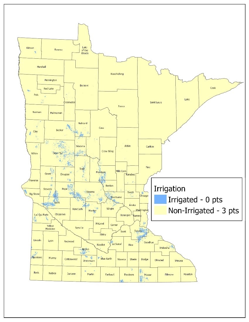
Irrigation Water Management is an important aspect for mitigating runoff. The EPA has designated several mitigations in relation to irrigation water management. Of these options, whether a site is irrigated or not remains fairly constant over time. Non-irrigated sites or dry-farming are worth three points toward meeting mitigation requirements. Other irrigation water management options are available but are based on in-field conditions and practices, see Mitigation Menu website for these options. Source USGS LANID.
Pre-Existing Practices
It is important to evaluate your sites to determine the number of mitigation points from existing practices. Credit is given for practices previously implemented that meet the criteria on the Mitigation Menu website. These points should be subtracted from the number of mitigation points required by the label.
Additional Mitigation Measures
Once relief points have been determined and subtracted from the labeled point requirements the remaining points must be achieved by implementing addition mitigation measures.
Example: Label requires nine mitigation points
Your site’s relief points:
- Slope <3%: 2 points
- No irrigation: 3 points
- EPA Runoff Vulnerability: 2 points
- Relief point total = 7 points
9 required points – 7 relief points = 2 points of additional mitigation measures needed
These mitigation options are composed of in-field and edge-of-field practices. The EPA has evaluated and assessed numerous practices and has selected options that are effective in reducing runoff and erosion. Practices like tillage regimes, certain irrigation water management practices, cultural practices, and edge-of-field practices vary in the number of points designated based on how effective the practice is at reducing runoff and erosion. For a complete list of mitigation options available, please visit the EPA’s Mitigation Menu website. This website will continue to be updated as EPA evaluates addition conservation practices.
Mitigation measures listed on the EPA's Mitigation Menu website are closely aligned with the National Resources Conservation Service (NRCS) practices. The NRCS conservation practice standards may act as a guide for implementing EPA's ESA mitigation measures. Additionally, one point is offered for consulting with a technical expert, or two points are offered for participating in a conservation program. Participating in the Minnesota Agricultural Water Quality Certification Program qualifies as an approved conservation program worth two points.
Lastly, documenting or tracking implemented mitigation measures is worth one point. The MDA recommends documenting the implementation of mitigation measures as well as other label requirements to help with compliance of these new requirements.
Last Updated: 7/17/2025