Principal Investigator: Karen Gran
Co-Investigators: Jeff Marr and Jessica Kozarek
Organization(s): University of Minnesota-Duluth, Department of Geological Sciences; National Center for Earth Surface Dynamics, St. Anthony Falls Laboratory, University of Minnesota
Sponsor: Clean Water Fund
Award Amount: $180,000
Start Date: 4/15/2012 | End Date: 6/30/2016
Project Manager: Margaret Wagner (Margaret.Wagner@state.mn.us)
FINAL REPORT is available in the Minnesota Water Research Digital Library
Martin Bevis, University of Minnesota-Duluth M.S. student, thesis on the bluff analyses and sediment budget compilation component of the project (February 2015)
Overview
 This project established a collaborative with the goal of developing a consensus plan for reducing sediment loading on the Greater Blue Earth (GBE) watershed. The project developed (i) a basis for forecasting changes in sediment loading in response to changes in land use, climate, and conservation practices and (ii) a decision-analysis system in which the costs and benefits of management alternatives can be evaluated in a consistent and transparent framework, incorporating the best available scientific information and accounting for uncertainty. The portion of the project funded by the Minnesota Department of Agriculture supported the assessment of conservation drainage practices, development of a sediment budget for the GBE to be used in a sediment simulation model that can accommodate changes in hydrology, and incorporation of this information into a stakeholder decision process for reducing sediment loads to meet TMDL targets.
Project Goal
The goals of this project were:
- To establish a sediment budget for the Greater Blue Earth (GBE) Basin and
- To evaluate the cost and efficiency of best management practices for reducing water and sediment delivery to the GBE stream channels.
 This research project and the related objectives are part of a larger research effort referred to as the Collaborative for Sediment Source Reduction project which is coordinated by the National Center for Earth Surface Dynamics which includes scientists from St. Anthony Fall Laboratory (SAFL) at the University of Minnesota, University of Minnesota-Duluth, Utah State University and Johns Hopkins University.
Background Information
Research Location
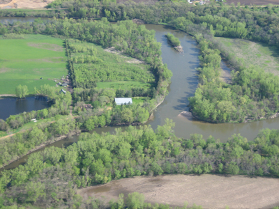
The Greater Blue Earth River Basin includes three major watersheds: Watonwan River, Le Sueur River and Blue Earth River and eleven counties in southern and southwestern Minnesota: Blue Earth, Brown, Cottonwood, Faribault, Freeborn, Jackson, Le Sueur, Martin, Steele, Waseca and Watonwan.
Objectives of the Project
Objective 1:
The goal of objective 1 is to extend the sediment budget compiled in the Le Sueur watershed (PDF) to the entire GBE watershed. This budget will be developed on an annual timescale for modern conditions and pre-settlement conditions. This work will include Light Detection and Ranging (LiDAR) and air-photo analysis to identify sediment sources, extrapolation of sediment source relations from the Le Sueur to the GBE, additional measurements of erosion rates on bluffs and channel banks in the GBE, and testing of the budget results against gauging and sediment fingerprinting results. This sediment budget will focus on fine sediment (silt and clay).
Objective 2: Establish efficiency and cost of conservation drainage and sediment reduction practices.
Although work to date (including watershed models and the spectrum of information used to develop the Le Sueur sediment budget) provides a sound basis for identifying sediment sources, planning for sediment source reduction depends also on the feasibility, effectiveness, and cost of conservation drainage and sediment reduction practices as a function of type, setting, and location. We will collaborate with stakeholders to identify the available suite of management actions and their cost and effectiveness.
For more detailed information about methods, please contact the MDA project manager, Heidi Peterson.
Deliverables
- Inventories of sediment sources including ravines, bluffs, and channels.
- A sediment budget assembled on a spreadsheet including the Le Sueur, Blue Earth, and Watonwan River basins including uncertainties.
- A pre-settlement budget derived from topographic and surficial geologic data as well as a study in the Le Sueur involving numerical modeling and terrace age control.
- A final report on current conservation drainage BMPs relevant to the GBE watershed including a table of management actions with their range of cost and effectiveness.
- A GIS model which will demonstrate BMP feasibility, effectiveness, and cost as a function of type, setting, and location.