Principal Investigator: Jeff Strock
Organization(s): University of Minnesota Southwest Research and Outreach Center
Award Amount: $183,910
Start Date: 7/1/2008 | End Date: 6/30/2011
Project Manager(s): Mark Dittrich (Mark.Dittrich@state.mn.us)
FINAL REPORT: Evaluation of Nutrient Retention Basins (PDF)
Featured Journal Article by Dr. Strock
Background and Introduction
 The goal of this project was to better understand and measure the effectiveness of nutrient retention basins on agricultural lands. Retention basins are essentially water storage areas; they are designed to temporarily store water while removing nutrients. Retention basins can be used to filter both surface and subsurface runoff and can be strategically placed within fields to optimize water quality benefits and farming practices.
This project compared three different nutrient retention basins, including surface, horizontal and vertical flow systems each using a different treatment mechanism.
Constructed nutrient retention basins have been successfully used in agricultural livestock production as an effective method of treating animal waste. It is unknown how effective and efficient constructed nutrient retention basins may be at removing agricultural contaminants from combined surface and subsurface drainage runoff under Minnesota conditions.
Specific Research Goals:
- Design and instrument a series of water and nutrient storage basins for the treatment of agricultural drainage water
- Collect water and nutrient data in order to assess the capacity of the designed systems to improve edge-of-field water quality
- Provide educational outreach on basin design, performance and the potential benefits of these systems
Methods
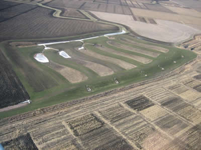
Replicated nutrient retention basins were designed and constructed in the fall of 2007 at the University of Minnesota, Southwest Research and Outreach Center (SROC) in Lamberton, Minnesota. The area consists of undrained Canisteo poorly drained soil. The area contributing runoff to the retention basins (~ 114 acres) was annually planted to corn and soybean.
Replicated constructed nutrient retention basin designs included pairs of surface-flow basins, subsurface-flow basins and vertical-flow basins.
- Surface-flow basins (SF) were designed so that incoming water principally flowed above the ground surface, through a dense growth of terrestrial and emergent aquatic plants.
- Subsurface-flow basins (HF) treated water by passing it horizontally through a permeable media planted with terrestrial and aquatic plants.
- Vertical flow basins (VF) are similar to subsurface-flow basins except that these systems were designed to treat water by passing it vertically through soil planted with terrestrial and aquatic plants.
Each basin occupied an area equal to approximately one-half acre. Water inflow to and outflow from the basins was monitored in order to quantify nutrient and water budgets for each of the three basin types.
Read the Final Report (PDF) to learn more about research site development, instrumentation and vegetation management.
Project Deliverables
- Equip the site with soil and water monitoring sensors and data loggers;
- Measure and report results on background levels of soil/sediment constituents including: nitrogen, phosphorus, carbon, sulfur, selected monovalent, divalent, and trivalent cations, mercury, and pH;
- Measure and report results on the effectiveness and efficiency of agricultural contaminant removal from three types of constructed nutrient retention basins designed to improve agricultural water quality. Data collected will include flow, nitrogen,phosphorus, water temperature, pH, conductivity, and dissolved oxygen from combined surface and subsurface runoff; and
- Inform stakeholders regarding nutrient retention basin designs, instrumentation, and performance.
Results
Nutrient Loads (summary table coming soon)
Nutrient loads, expressed as percent difference between the inflow and outflow, are presented by year but only reflect loads during the period generally between March and November (frost free periods). Loads for 2011 are only for the period January through June when surface runoff, subsurface drainage, or snowmelt occurred. The lack of nutrient load data for Surface Flow (south) inlet and Subsurface Flow (north) outlet were the result of a programming problem and in the case of Surface Flow (south) a rodent infestation that has since has been taken care of.
Phosphorus
Reductions in phosphorus were observed for Total Phosphorus (TP) and Dissolved Molybdate Reactive Phosphorus (DMRP) for both years. Reductions in P were generally greater than 50% when comparing the inlet load to the outlet load for 2010 and similar for the first half of 2011.
Researchers made no attempt to infer the process or mechanism of phosphorus removal from drainage waters, however, it is likely that vegetative uptake and deposition of some phosphorus associated with sediment occurred.
Nitrogen
There were relatively high loads of nitrogen during 2010 and 2011. These can be attributed to subsurface drainage that lasted well into the summer of 2010 due to excess precipitation during June through September. For the first half of 2011, there was 7 cm of subsurface drainage. Subsurface drainage is generally the main source of dissolved nitrogen entering surface waters. During a typical year, subsurface drainage begins in mid-March and ends by mid-July.
In general, the basins were effective in removing nitrate-nitrogen from drainage water. In 2011, the Vertical Flow (south) inflow and outflow loads were similar. At this point we have no reasonable explanation for this phenomenon.
During both years the Vertical Flow basins were effective in removing dissolved ammonium–nitrogen from the drainage water. This was likely do to sorption onto the surface of soil particles as the water filtered through the soil.
Environmental and Engineering Issues
Unfortunately, during spring 2010 excess snow prevented installation of monitoring and sampling equipment which consequently limited early season data collection for these locations. Another complicating factor involved in missing early season flow measurements was a departure from the planned elevation of the large concrete approach sections (approach section refers to the area leading up and contributing water to the retention basins). The approach sections were adjusted accordingly to ensure flow was equal entering each of the basins.