Principal Investigator: Patrick Belmont
Co-Investigator: Jane Willenbring
Organization: University of Minnesota, National Center for Earth-surface Dynamics; Utah State University, Department of Watershed Sciences
Award Amount: $65,298
Start Date: 5/18/2008 | End Date: 4/20/2011
Project Manager: Adam Birr
FINAL REPORT: Tracing Sediment Sources with Meteoric 10Be: Linking Erosion and the Hydrograph (PDF)
Project Goal
The goal of this project was to develop and implement a sediment fingerprinting approach that can be used to determine the proportion of sediment derived from upland versus near-channel sources (banks, bluffs, and ravines) in the Le Sueur River watershed, south-central Minnesota.
This information can be used to help inform what type of management/conservation/restoration work might be needed and for evaluating the post-project effectiveness of such work.
Background
Currently, sediment is one of the leading causes of impairment in rivers of the US and globally. Despite extraordinary efforts, sediment remains one of the most difficult non-point source pollutants to quantify at the watershed scale.
Developing a predictive understanding of watershed sediment yield has proven especially difficult in flat landscapes. Challenges arise due to several common features of these landscapes, including:
- source and sink areas are defined by very subtle topographic features that often cannot be detected even with relatively high resolution topography data,
- humans have dramatically altered water and sediment routing processes, the effects of which are exceedingly difficult to capture in a conventional watershed hydrology/erosion model and
- as sediment is routed through a river network it is actively exchanged between the channel and floodplain, a dynamic that is difficult to model at the appropriate scale.
While models can be useful to understand sediment dynamics and to predict changes in sediment flux and water quality in response to management actions in a watershed, several key processes are difficult to constrain. Direct measurement of erosion, deposition and sediment transport at key locations (edge-of-field, eroding channel banks) are also useful and can help constrain the existing models, but such efforts are costly and are inherently limited in spatial extent, sampling frequency, and level of detection.
Sediment fingerprinting
Sediment fingerprinting is a relatively new technique that addresses many of the key limitations of other approaches for quantifying sediment sources and understanding sediment transport. When used in combination with other approaches sediment fingerprinting can provide useful information for calibrating/validating computer models and/or upscaling local measurements of erosion and deposition.
Sediment fingerprinting utilizes the geochemical composition of suspended sediment to determine the proportion derived from different parts of a watershed. This sediment fingerprinting research utilized a suite of long- and short-lived radionuclide tracers (specifically, Beryllium-10 (10Be) with a half-life = 1.36 x 10⁶ years, Lead-210 (210Pb) with a half-life = 22.3 years, and Cesium-137 (137Cs) with a half-life = 30 years) associated with source areas and suspended sediment.
- Beryllium-10 and 210Pb are both naturally occurring isotopes that are continually produced in the atmosphere, delivered via dry deposition and/or during rain events, and adsorb tightly to soil particles within the top 5-10 and 150 cm of the soil profile for 210Pb and 10Be, respectively.
- Cesium-137 was delivered as a result of nuclear bomb testing, primarily between 1955 and 1963.
The Minnesota Department of Agriculture grant supporting this work focused exclusively on the 10Be results and for that reason, those results are the primary focus of this summary.
Study Area
The Le Sueur River drains a 2880 km2 area and is a major source of sediment to the Minnesota and upper Mississippi rivers (according to the Minnesota Pollution Control Agency (MPCA)). However, uncertainty exists regarding the relative importance of different sediment sources. The primary potential sediment sources are bluffs (tall, cliff-like features that are typically composed of fine-grained till), ravines (steep, first- and second-order fluvial networks that connect uplands with the river valley), streambanks (fluvial features that define the river channel) and uplands (of which 92% are used for agricultural row crop production).
Methods
Three general types of sediment samples were collected and analyzed for 10Be, they are referred to as source samples, suspended sediment samples, and lake core samples.
Source samples include any sediment collected directly from a source area (upland, bluff, ravine, or streambank/floodplain). Source samples were collected by manual grab samples using a shovel or soil auger. Locations were selected systematically to represent several different parts of the watershed.
Suspended sediment samples refer to Total Suspended Sediment (TSS) samples collected during or immediately following storm events from one of the gaging stations on the Le Sueur River or its tributary, the Maple River. Suspended sediment samples were collected at various gaging stations located throughout the watershed.
Lake Core samples were collected from sedimentary deposits in Lake Pepin (sample material collected by previous research projects and provided for analysis within the scope of this project by Science Museum of Minnesota, St. Croix Watershed Research Station).
All samples were analyzed at Purdue University Rare Isotope Measurement (PRIME) Laboratory for meteoric 10Be extraction and measurement.
Results
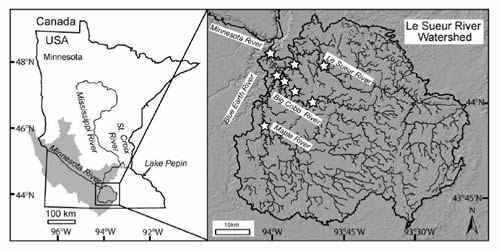
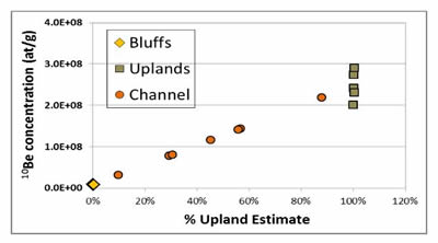
This study used two end-member mixing analysis which assumes that the river water sampled is 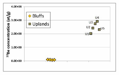 made up of a mixture of waters supplied by distinct sources of the watershed, each with distinct concentrations of 10Be. The two end-member sources in the Le Sueur River for geochemical fingerprinting with 10Be are uplands and bluffs. Uplands, having been exposed to atmospheric deposition of 10Be for many millennia were expected to exhibit significantly higher concentrations compared with bluffs, which have typically only been exposed to atmospheric deposition for a few years or at most, decades.
If a sediment sample had a higher concentration of 10Be, (2.0E+0.8 – 3.0E+08) researchers suggest a greater percentage of that sediment was derived from uplands, and if there was a lower 10Be concentration (0.0E+00 – 1.0E+08) they suggest a greater percentage of that sediment was derived from bluffs. The 10Be concentration of sediment samples collected from stream channels, floodplains and ravines fall between these high and low values. This enables researchers to assess what proportion/percentage of sediment was derived from either bluffs or uplands.
Source Samples
Samples were strategically collected from several different locations in numerous ravines, and showed that ravine sediment can vary across nearly the full range of 10Be concentrations observed between the two end-member sources.
Samples collected directly from ravine hillslopes fall within the range of 1.2E+08 to 2.1E+08, as expected because the ravine soil surfaces are expected to have been eroding at a rate that falls between that of the uplands and bluffs.
Suspended Sediment Samples
The 10Be concentration in the suspended sediment samples reflect the proportion of sediment derived from different sources at a particular point in time. Researchers collected TSS samples from gages located above the knickpoint and within the knick zone.
 While there is overlap between the two populations, there is a general shift to lower concentrations at the lower gages, as expected from a higher proportion of bluff inputs within the knick zone.
Lake Core Samples
The low 10Be concentration measured in sediment delivered to Lake Pepin 500 years ago indicates very little upland soil erosion relative to bluff erosion at that time. During the mid-1900s, an increase in 10Be concentrations indicates a pulse of soil erosion from agricultural fields. Over the past three decades, both tracers indicate shifts back toward near-channel sources. The interpretation of this trend is that upland soil erosion may have declined in response to the emergence of precision-agriculture practices and enhanced conservation efforts. However, any reduction in sediment inputs from these activities has been offset by an increase in near-channel erosion, resulting from dramatic increases in high flows.
This shift in sources is further supported by the sediment budget developed at the much smaller scale of the Le Sueur watershed which uses multiple lines of information to pinpoint near-channel erosion as the dominant source during the time period 2000 to 2010.