Principal Investigator: Chris Lenhart
Co-Investigator: John Nieber
Organization(s): University of Minnesota, Department of Bioproducts and Biosystems Engineering
Award Amount: $288,650
Start Date: 4/15/2011 | End Date: 06/30/2015
Project Manager(s): Heidi Peterson
FINAL REPORT is available in the Minnesota Water Research Digital Library
Overall Goal of the Project
The goal of this project is to develop a scientifically defensible approach for prioritizing stream sites with the intent of reducing sediment and phosphorus loading. The idea is that stream sites that contribute the largest amount of sediment and phosphorus should be prioritized and conservation practices should be targeted to these areas. The new approach will use the Priority Management Zone (PMZ) concept and be tested on three proposed sentinel watersheds.
Project Update 6-18-2014
Several tools have been developed for prioritizing stream corridor management actions. These tools included a lateral migration GIS tool developed in collaboration with the MN DNR. This tool is providing a broad indication of where the greatest rates of channel migration are occurring in the Whitewater, Buffalo Red and Elm Creek watersheds. Additionally, an approach was developed for doing a rapid field inventory of the Bank Erosion Hazard Index (BEHI) values which can be used to better understand bank erosion processes and refine the selection of sites for potential restoration and management projects. Resource managers could use this information to narrow the number of sites to consider for projects. Lastly, a method for prioritizing specific stream sites for restoration based on logistical issues (such as cost, accessibility and landowner willingness) and secondary benefits (aesthetic and ecological attributes such as additional structure for fish or invertebrates).
Lessons learned to date:
- A large percentage of sediment production from stream channel erosion is often concentrated in a relatively small geographic portion of the watershed. Improved targeting of riparian zone management practices could help reduce sediment loading and improve local in-stream conditions for biota (fish, insects, etc).
- The BEHI tool combined with estimates of near bank shear stress via the BANCS equation can provide a straightforward estimate of annual channel erosion if calibrated for each region. This information is helpful to managers for prioritizing stream sites and making decisions about the types of riparian practices that are most suitable for a given stream type and watershed (geographical) setting.
- The lateral migration tool is very effective for prioritizing stream bank project sites, but is not as useful for ravines where the erosion is mostly down-cutting. Also since ravines are mostly wooded they are nearly impossible to digitize in GIS.
In the second part of the study, a preliminary model of water sources in Elm Creek has been developed for understanding how hydrologic drivers contribute to bank erosion events. Specific conductivity (SC) is used as an indicator of groundwater contribution to stream flow. Collecting SC samples from streams, groundwater wells, tile outlets and other sources enables us to determine where water within the stream is originating from at different times of the season and flow stages (high flow, low flow, base flow). Groundwater tends to have a high SC signature since water that has a long contact period with soil has dissolved more minerals. Distinct signatures were identified for groundwater, tile drainage, snowmelt, stream flow and rainfall with the help of dataloggers that provided tens of thousands of data points in 2013-2014. Hydrogen and Oxygen isotopes are used as a “surface water identifier” since surface water that has undergone evaporation has more concentrated 18O and 2H (deuterium) isotopes. This project used geochemical indicators (isotopes), a SWAT model and flow monitoring data as multiple lines of evidence to help characterize water sources and flowpaths. This information is very useful to managers when selecting practices for reducing stream flow. For example, if most water is coming from subsurface tile flow then more controlled drainage and use of perennial plants to reduce soil moisture are needed. If water at high flow events is primarily surface runoff than more water storage ponds, wetlands and low-till/no-till practices should be prioritized.
Future work may include the development of maps showing lateral migration rates in each ecoregion of the state and by channel type. Refinement of management practice recommendations in riparian zones is needed as well.
Background Information
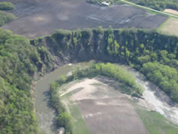 Studies in Minnesota, Wisconsin and Iowa indicate that stream channel erosion (stream banks, ravines and bluffs) is the major source of sediment and phosphorus in many agricultural watersheds. The accumulation of fine sediments and filling of pools can have negative effects on the health of the stream environment.
While channel erosion is a natural process, the rates observed in the Minnesota River basin and other parts of the Midwest exceed natural background/ historical levels. Consequently, there is a need to reduce channel erosion where it is excessively high and develop a way to prioritize erosive sites to have the greatest overall reduction of sediment and phosphorus loading to rivers and streams.
At this time there are numerous tools that exist to quantify the amount of erosion occurring. Some of these tools are very complex while others are available for general use. The most complex tools are robust and describe erosion processes in more detail, but require extensive training for use and interpretation. Tools that are developed for general use are often less accurate and may not provide enough information for effective conservation planning. This project will develop an intermediate approach; an empirically-based index that is applicable to the Upper Midwest and also usable by local government agencies and conservation professionals. Research into the geomorphic and hydrologic processes driving erosion will be examined in detail to provide the necessary scientific-background for the broadly applicable tool.
How to Build this New Model
- Use GIS and field based methods to produce a modified Bank Assessment for Non-point source Consequences of Sediment (BANCS) model
- This project will develop a modified BANCS model and calibrate it for different geomorphic regions of Minnesota using monitoring, modeling and historical data.
- The Bank-Stability and Toe-Erosion Model (BSTEM) or CONCEPTS will provide physical modeling to support the empirically-based BANCS predictions of channel erosion
- The BSTEM model and CONCEPTS model both quantify the risk of bank collapse based on physical properties of the stream bank such as slope, cohesive strength and soil water level.
- BSTEM predicts erosion quantities from individual storm events, while CONCEPTS can model erosion, deposition and channel evolution over extended time periods.
- Hydrologic pathways and drivers of erosion will be quantified using stream flow records collected at the watershed scale in conjunction with isotopic and geochemistry data to characterize the source of water as groundwater, tile flow or surface runoff.
This analysis will be conducted in three different geomorphic regions:
- Whitewater River in the Driftless Area in southeast Minnesota
- Elm Creek within Glacial Till Plains of the Blue Earth Basin in southern Minnesota
- Buffalo River within the Red River of the North Basin
These analyzes and assessments will be used to identify priority management zones (PMZs) for the intended purpose of reducing sediment and phosphorus loads in sentinel watersheds.
What is a sentinel watershed?
Sentinel watersheds are areas that are representative of other watersheds in the same region. The idea is that once models are developed for the sentinel watershed, these models can then be used to predict rates of channel erosion in other areas within the region. Identifying sentinel watersheds reduces the amount of time and money required to estimate channel-derived sediment and phosphorus loading.
What is a PMZ?
Priority Management Zones (PMZs) are regions of the watershed targeted for conservation practices that address disproportionate or large pollutant loads. PMZs can be characterized by three areas of emphasis: source reduction, interception treatment, and in-channel assimilative capacity.
Building on Past Work
Projects sites were selected due to substantial activity already ongoing within each of the watersheds. This project will build on a previous Ravine, Bluff and Stream bank (RBS) erosion study that was supported by the Minnesota Pollution Control Agency (MPCA) and Minnesota Corn Growers Association. It will also build on work being done by the Minnesota Department of Natural Resources (DNR) in the Buffalo River watershed in northwestern Minnesota. A grant from the McKnight Foundation will provide additional resources to develop a strategy for planning restoration projects for sediment reduction and to evaluate economic and social aspects of channel erosion reduction.
Research Objectives
- Develop channel erosion assessment tools that are applicable to three regions of Minnesota
- Tools are being developed and tested in regions that represent proposed sentinel watershed
- Assess the hydrologic drivers that are associated with the sources of channel derived sediment
- This will help to determine the proportion of stream flow from surface water or groundwater. Proper source water identification is critical for developing appropriate sediment mitigation measures.
- Estimate the natural/background/baseline erosion for representative channels in each of the sentinel watersheds
- Develop the decision support tool for prioritizing channel restoration and sediment reduction within the sentinel watersheds
- Identify PMZs for channel-derived sediment and phosphorus to determine what types of treatment would be most practical and applicable for the goal of sediment and phosphorus reduction