Principal Investigator: David Mulla
Organization(s): University of Minnesota, Department of Soil, Water, and Climate
Award Amount: $160,000
Start Date: 3/1/2007 | 6/30/2009
Project Manager(s): Adam Birr
FINAL REPORT: Evaluation of Best Management Practices in Impaired Watersheds using the SWAT Model (PDF)
The Soil Water Assessment Tool (SWAT) is a watershed-scale model; it is primarily used to predict and evaluate the effect of long-term land cover and land management practices on the quantity and quality of water that is exported from a watershed. This model can estimate the amount of water that contributes to stream flow and the relative sediment, nutrient, and pesticide losses under different agricultural field conditions and management scenarios.
Output from this model can be used to identify critical portions of the landscape; areas that may disproportionately contribute sediment or nutrients to water ways. If management efforts to reduce runoff are targeted to high priority areas, for example land with a >2% slope, pollutant loads may be dramatically reduced. Identification of these critical areas is essential for the effective and efficient implementation of agricultural management practices.
What is a watershed?
A watershed is the land area where all the water that falls in it or that drains into it goes to the same place. A watershed is simply the land area that drains into a common lake, river, stream or ocean.
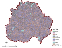
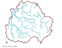
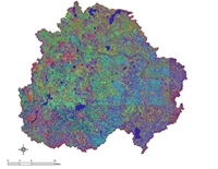
Input GIS data layers used to build the SWAT Model
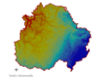
Digital Elevation |
|
|
|
The research objectives for this project were:
- To investigate and test applicability of the SWAT hydrologic model under the climate, farming systems, hydrologic and physiographic conditions of Minnesota.
- To accurately and efficiently quantify sediment, nutrient (nitrate-nitrogen, phosphorus) and pesticide (atrazine, acetochlor, and metolachor) losses from the Le Sueur River and South Branch of the Root River watersheds.
- To identify and prioritize critical sub-watersheds and to evaluate the relative importance of managing them.
- To evaluate the effectiveness of alternative best management practices (BMPs) at reducing pollutant loads from two southern Minnesota watersheds.
This research project evaluated the delivery of sediments, nutrients and pesticides under different management scenarios. Management strategies included conservation tillage, no tillage, vegetative filter strips, buffer strips, cover crops, reduced fertilizer and pesticide rates, alternative timing of pesticide and fertilizer, and incorporation of pesticides.
Estimates of pollutant loading reductions resulting from various BMPs : Le Sueur River watershed
- Modeling showed that 21% of the sediment load at the mouth of the Le Sueur River watershed was a direct contribution from upland agricultural sources
- Upland sediment loads can be reduced by 12% by implementing conservation tillage on all corn residues from slopes steeper than 2%. Installing grass filter strips on all cropped landscapes steeper than 2% provides a 56% reduction in sediment losses.
- Phosphorus (P) losses can be reduced by 28% using reduced application rates of fertilizer.
- Conservation tillage on corn residue in fields steeper than 2% reduced P losses by 15%.
- Installation of grass filter strips on all cropped landscapes steeper than 2% reduced P losses by 64%.
- Planting a fall cover crop of rye reduced P losses by 29% and nitrate-nitrogen (N) losses by 16%.
- Reducing the rate of fall applied anhydrous ammonia reduced nitrate-N losses by 20%.
- Buffer strips installed in critical areas are very effective at reducing acetochlor losses.
- It is important to apply acetochlor well in advance of spring rainstorms to reduce losses.
Findings from this study can provide immediate input in the development of total maximum daily loads (TMDLs) for watershed located in portions of southern and southeastern Minnesota.
More details about both the Le Sueur River and South Branch of the Root River watersheds can be found in the following document: Evaluation of BMPs in Impaired Watersheds using the SWAT Model (PDF).
Deliverables
- A report evaluating the performance and applicability of the SWAT model for TMDL applications
- Estimates of the load allocations of sediment, P, nitrate-N, acetochlor, metolachlor, and atrazine in the pilot watersheds
- Estimates of pollutant load reductions resulting from various BMP implementation strategies