Principal Investigator: Patrick Belmont
Co-Investigator: Toby Dogwiler
Organizations: Utah State University, Department of Watershed Sciences and Winona State University, Southeastern Minnesota Water Resources Center
Award Amount: $227,658
Start Date: 6/1/2012 | End Date: 12/30/2015
Project Manager: Kevin Kuehner (Kevin.Kuehner@state.mn.us)
FINAL REPORT is available in the Minnesota Water Research Digital Library
Background
 Sediment is a natural part of river ecosystems. Yet, in excess quantities, or in cases where the type of sediment contributed to a river has been severely altered (e.g. gravel inputs eliminated, silt and clay inputs increased), sediment can severely degrade water quality and aquatic ecosystem health. This problem is exceedingly common.
While previous research has advanced our understanding of water-sediment dynamics, several key questions remain. This research project will:
- Provide specific information regarding sediment sources and transport pathways in the Root River watershed
- Determine how water and sediment dynamics have changed over time
- Provide guidance for best management practices (BMPs) at reducing sediment delivery to the Root River
Researchers will compile existing data, and generate several new, critical datasets to develop a comprehensive assessment of sediment-related impairments in the Root River.
What is a sediment budget?
A sediment budget is an approach used to determine the relative sources of sediment from various erosion processes, natural and management-related. A complete sediment budget considers the sources and storage of sediment and the export of sediment from the watershed.
Why the Root River?
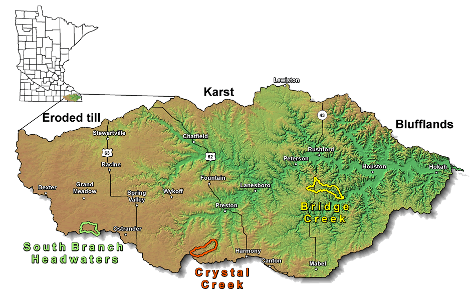
The Root River is a large and unique watershed located in southeastern Minnesota.
This area supports a diverse agricultural sector and a broad range of outdoor activities. The Root River watershed has high agricultural productivity, yielding abundant corn, soybeans, beef and pork. In addition, this area provides abundant recreational opportunities including canoeing, bicycling, camping, hiking, hunting and fishing. There are two state parks (Beaver Creek Valley and Forestville-Mystery Cave) and two trout hatcheries that draw visitors and anglers from around the state and region.
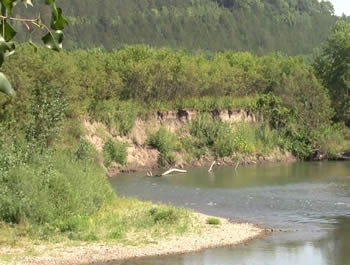
Excessive sedimentation is among the top water quality concerns in the Root River watershed. This concern must be addressed in order to protect the agricultural economy, tourism and outdoor industries that are so important to this area.
The Root River contains 43 impaired reaches (segments of the river), the vast majority of which (72%) are impaired for turbidity or Mercury (MPCA, 2010).
Objectives
1) Develop an integrated sediment budget, which compiles multiple, redundant sources of information (including sediment fingerprinting, aerial and terrestrial LiDAR analyses, air photo analyses, field surveying and mapping, water and sediment gaging information, and modeling), that can be used to identify the most important sediment sources, processes acting on those sources, potential for sources to be mitigated.
2) Conduct a hydrologic analysis to understand how discharge and related metrics (e.g., runoff ratio) scale throughout the watershed.
3) Develop a model illustrating how sediment is routed downstream, which will inform our understanding of how sources and sinks influence routing and the lag times to be expected between implementation of BMPs and observable improvements in water quality.
4) Develop and distribute computational tools that can be used for source identification and feature extraction from high resolution (LiDAR) topography data.
Materials and Methods
Sediment Fingerprinting
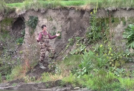 Sediment fingerprinting is an analytical method used to determine different sources of sediment from various erosion processes, both natural and management-related. The underlying principle is that different sediment sources (i.e stream banks, in-stream channel stream beds, floodplains, and uplands) can be characterized using a number of chemical and physical properties. Each source of sediment has a unique set of properties, referred to as a “fingerprint”.
The source sampling will be used to: a) better define the concentrations of the tracers derived from different sources of sediment within the watershed; b) characterize floodplain deposition rates and floodplain/bank tracer concentrations; and c) determine the extent to which groundwater seeps may influence fingerprinting estimates.
Lidar Analyses
Light Detection and Ranging (LiDAR) is an optical remote sensing technology. In this project it is being used to extract stream cross sections, detect bank locations, and identify geomorphic bankful water surface elevation. This data will be used to constrain the net amount of sediment contributed from bank erosion. The LiDAR data will also be used to identify and prioritize the erosion pathways across the landscape that link critical source areas with surface streams.
Air Photo Analyses
Historic air photos contain important information about how land use and channel morphology have changed over time. Researchers will conduct comprehensive analyses of changes in land use, as well as channel width and meander migration over time.
Researchers will document changes in vegetation type, channel widening and meander migration rates, and also evaluate the effects of current and historical small dam structures within the watershed.
Hydrologic Analyses
Researchers will collect hydrologic data from the local Soil and Water Conservation Districts (SWCDs), Natural Resource Conservation Service (NRCS), Minnesota Department of Agriculture (MDA), Minnesota Pollution Control Agency (MPCA), United States Geological Survey (USGS), Minnesota Department of Natural Resources (MNDNR), and other organizations. Understanding if/how the hydrology has changed throughout the watershed will help to pinpoint locations in the watershed that may require more detailed study for the sediment budget.
The hydrologic analysis will be sub-divided into two tasks:
1) Determine if/how the intensity, frequency, and duration of rainfall events has changed, with a specific focus on understanding extreme events;
2) Examine relationships between rainfall and runoff throughout the watershed, determine if/how these relationships vary spatially and if/how they have changed over time.
Water and Sediment Gaging
Researchers will work directly with MDA, MPCA, Fillmore County SWCD, and others to compile existing water and sediment monitoring data. Also, they will perform new analyses to understand hydrologic scaling and identify sediment source/sink hotspots, and establish several new monitoring sites in key locations to fill data gaps.
Field Surveys and Mapping
Researchers will augment the remote sensing-based analysis of changes in channel morphology and pattern with in-stream geomorphic surveys. These surveys will provide a means to assess changes in near-channel sediment flux due to the significant disturbance caused by the 2007 and 2008 floods in the watershed. The in-stream surveys will also provide ground-truthing (validation) of the stream geomorphic data that will be compiled via remote sensing techniques (see above in the ‘Lidar Analysis’ and ‘Air Photo Analysis’ sections).
Project Completed: May 2016
Final report includes:
1) A complete sediment budget for the entire Root River watershed as well as several sub-watersheds, as available data permitted.
2) Maps, provided as GIS layers, indicating primary sources and sinks throughout the watershed as well as clear indication of active locations for sediment exchange.
3) A comprehensive hydrologic analysis of if/how and where flow metrics have changed throughout the watershed as a result of human and natural changes. As appropriate, implications for erosion and sediment transport are articulated.
4) A concise and spatially-explicit explanation of which BMPs will be most effective in different parts of the Root River watershed and estimates of the timeframes over which BMPs implemented are expected to result in improved water quality.
5) Peer-reviewed publications and presentations resulting from this project will be listed as they become available.